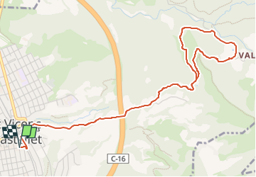
![](/images/other/stat-length.png)
![Tour Zu Fuß Sant Vicenç de Castellet - SL-C 53 De Sant Vicenç de Castellet a Sant Pere de Vallhonesta - Photo](https://media.geolcdn.com/t/1900/400/c31d6cc3-db2c-488e-bd2c-30f798f6fc71.jpeg&format=pjpeg&maxdim=2)
SL-C 53 De Sant Vicenç de Castellet a Sant Pere de Vallhonesta
SityTrail - itinéraires balisés pédestres
Tous les sentiers balisés d’Europe GUIDE+
![Länge](/images/other/stat-length.png)
![Maximale Höhe](https://static1.geolcdn.com/siteimages/upload/files/1508320355ic_sort_altitude_max_24dp.png)
![Positive Höhendifferenz](https://static1.geolcdn.com/siteimages/upload/files/1508320355ic_sort_den_pos_24dp.png)
![Km-Effort](/images/other/stat-length.png)
![Min. Höhe](https://static1.geolcdn.com/siteimages/upload/files/1508320355ic_sort_altitude_min_24dp.png)
![Negative Höhendifferenz](https://static1.geolcdn.com/siteimages/upload/files/1508320355ic_sort_den_neg_24dp.png)
![Boucle](https://static1.geolcdn.com/siteimages/upload/files/16400158638029165_repeat_loop_refresh_sync_direction_icon.png)
![Zu Fuß](https://static1.geolcdn.com/sitytour/trail-icons/100.png)
2h19
Schwierigkeit : Einfach
![Scannen Sie diesen QR-Code, um die Tour in der SityTrail-Anwendung zu öffnen](https://capi.geolives.com/qq0zvz2zws4bq2lad0pu/sitytour/trails/3108730/qr.png?size=200)
Kostenlosegpshiking-Anwendung
Über SityTrail
Tour Zu Fuß von 6,9 km verfügbar auf Katalonien, Barcelona, Sant Vicenç de Castellet. Diese Tour wird von SityTrail - itinéraires balisés pédestres vorgeschlagen.
Beschreibung
Trail created by Diputació de Barcelona. Parcs Naturals.
Symbol: parallel green and white horizontal bar
Website: https://view.gooltracking.com/dibaparcs/routes/view/sl-c-53-de-sant-vicenc-de-castellet-a-sant-pere-de-vallhonesta
Ort
Kommentare
Touren in der Umgebung
![Tour Zu Fuß Rellinars - SL-C 55 les Fonts de Rellinars - Photo](https://media.geolcdn.com/t/375/260/ec6dde9e-2bf8-4069-a0fd-c5f654caee2c.jpeg&format=jpg&maxdim=2)
![Zu Fuß Zu Fuß](https://static1.geolcdn.com/sitytour/trail-icons/100.png)
Zu Fuß
![](/images/other/stat-length.png)
![](https://static1.geolcdn.com/siteimages/upload/files/16400158638029165_repeat_loop_refresh_sync_direction_icon.png)
![Tour Zu Fuß Manresa - M3 - Itinerari Els pous de glaç i la riera de Guardiola - Photo](https://media.geolcdn.com/t/375/260/4f1927cb-9aa6-43c9-befe-496dcb61df62.jpeg&format=jpg&maxdim=2)
![Zu Fuß Zu Fuß](https://static1.geolcdn.com/sitytour/trail-icons/100.png)
Zu Fuß
![](/images/other/stat-length.png)
![](https://static1.geolcdn.com/siteimages/upload/files/16400158638029165_repeat_loop_refresh_sync_direction_icon.png)
![Tour Zu Fuß Rellinars - SL-C 57 La pedra seca - Photo](https://media.geolcdn.com/t/375/260/db68a2b0-a01b-419f-921f-e4671d311d8d.jpeg&format=jpg&maxdim=2)
![Zu Fuß Zu Fuß](https://static1.geolcdn.com/sitytour/trail-icons/100.png)
Zu Fuß
![](/images/other/stat-length.png)
![](https://static1.geolcdn.com/siteimages/upload/files/16400158638029165_repeat_loop_refresh_sync_direction_icon.png)
![Tour Zu Fuß Sant Vicenç de Castellet - SL-C 61 A Sant Jaume de Vallhonesta pel camí dels Maquis - Photo](https://media.geolcdn.com/t/375/260/68bced3e-fcd8-40aa-b6a7-8fa06895bec3.jpeg&format=jpg&maxdim=2)
![Zu Fuß Zu Fuß](https://static1.geolcdn.com/sitytour/trail-icons/100.png)
Zu Fuß
![](/images/other/stat-length.png)
![](https://static1.geolcdn.com/siteimages/upload/files/16400158638029165_repeat_loop_refresh_sync_direction_icon.png)
![Tour Zu Fuß el Pont de Vilomara i Rocafort - SL-C 52 El Pont de Vilomara - Photo](https://media.geolcdn.com/t/375/260/d5a0a28b-c408-4b5d-a2d2-e97ea669a8b0.jpeg&format=jpg&maxdim=2)
![Zu Fuß Zu Fuß](https://static1.geolcdn.com/sitytour/trail-icons/100.png)
Zu Fuß
![](/images/other/stat-length.png)
![](https://static1.geolcdn.com/siteimages/upload/files/16400158638029165_repeat_loop_refresh_sync_direction_icon.png)